Building a National Offshore Sand Inventory

Outer Continental Shelf (OCS) sand and gravel resources are vital sources of material for the construction of coastal protection and restoration projects, including efforts to protect coastal communities, national defense facilities, and federal and state infrastructure. In recent years, there has been a growing demand for OCS sediment for planned projects, as well as for emergency needs to restore areas damaged by natural disasters.

At the same time, proponents of planned infrastructure projects are requesting larger volumes of OCS sediment, driven by diminishing resources in state waters and the frequency and magnitude of recent storms along the Atlantic and Gulf of Mexico coasts. Further, given the significant number of other ocean users (e.g., energy infrastructure, fiber optic telecommunication cables, electrical transmission lines, and fisheries), BOEM strives to reduce or eliminate the potential for multiple use conflicts or environmental impacts that could result from marine minerals projects. This can make it challenging to identify new potential project areas.

As the sole steward of OCS marine minerals, BOEM needs to understand where sand resources are located and how much may be available for coastal protection and restoration projects. On a national scale, little is known about the character, quantity, and location of sand resources on the OCS and the habitat it provides for biological communities. These sand resources are most critical along the Atlantic and Gulf coasts, with an evolving interest in the Pacific and Alaska regions.

screen shot of the MMIS - Marine Minerals Information System
MMIS - Marine Minerals Information System

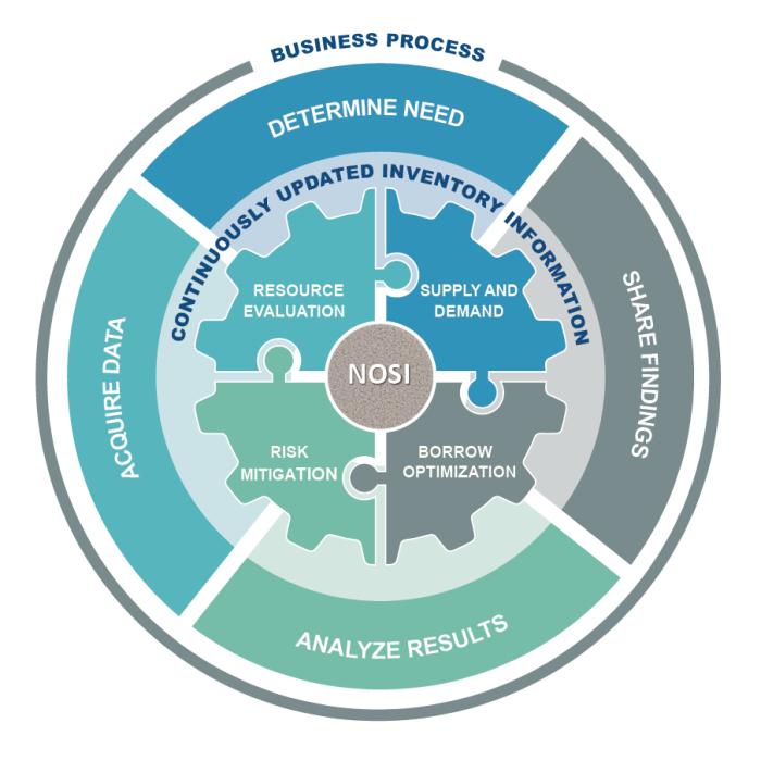
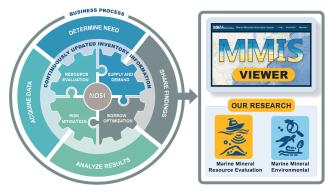
To meet these challenges, BOEM has launched the Marine Minerals Information System (MMIS) as part of the National Offshore Sand Inventory to help to reduce response time in disaster recovery and facilitate long-term planning to strengthen the resilience of coastal communities and infrastructure. Ensuring all parties have access to detailed offshore information is critical to responsible decision-making. To learn more about the inventory, watch this presentation: https://www.youtube.com/watch?v=y-ToyIleBdM.

Benefits of the MMIS:

By consolidating offshore sediment data from multiple sources, notably BOEM-funded research, the MMIS offers a one-stop, state-of-the-art interactive tool that provides public access to data and information relevant to offshore mineral resources throughout the U.S. Atlantic, Gulf of Mexico and Pacific OCS. It is accessible at https://mmis.doi.gov/BOEMMMIS.


Key MMIS Features:

  • More than 30 years of BOEM-funded geological and geophysical research data
  • Data from more than 40 partners in federal, state and local government, academia and other entities
  • A viewer with more than 20 available data layers
  • Sediment data offshore 18 coastal states
  • GIS-mapping capabilities
  • Tools to download data into geodatabases, shapefiles, or .csv files
  • Statistics on sand volume, number of projects, number of states, and use trends
  • Links to environmental studies and assessments, data from state cooperative agreements


How do I access and use MMIS data services 

The MMIS data is registered on the MarineCadastre. The two systems communicate with each other to enable data discovery.

By selecting any of the data layers on the MMIS, the interactive map viewer allows users to easily download, visualize, and explore geographic data about non-energy offshore materials. More than 20 data layers are available in the viewer, and may be downloaded in several formats (e.g., geodatabase, shapefile, or .csv files). Map-based queries enable users to find relevant marine minerals information products, which have been generated from other authoritative sources. MMIS User Outreach

Marine castrate s

Map from the MarineCadastre shows MMIS Atlantic OCS sand resource areas and ocean uses.

What types of information does the MMIS contain? 

Through the MMIS, users can find information about marine minerals lease areas, core sample information derived from multiple sources, and identified sand sources. The system pulls from more than 30 years of BOEM-funded geological and geophysical research, much of it previously stored on CDs and in PDFs and providing the historical organization for the database. The MMIS is the result of coordination through our partnerships with other federal agencies and state and local governments, particularly research conducted through our cooperative agreements with states.

What is on the dashboard? 

The easy-to-navigate dashboard shows information on a local, state and national level, including sand volumes leased, lease and nourishment sites, miles of coastline restored, and the number of projects.

The dynamic dashboard only displays leasing information stored in the database.

New MMIS Dashboard

Sample dashboard view

Does the MMIS provide environmental data? 

The MMIS provides citations for BOEM environmental study reports and environmental assessments through the Environmental Studies Program Information System (ESPIS)  or through MMP in Your State pages, and includes topics such as sea turtle behavior or habitat, and fish use of shoal habitat in specific offshore areas. Geological and geotechnical data are incorporated into the MMIS to help future analysis and inform reviews under the National Environmental Policy Act (NEPA) process.

Where can I find additional information on offshore sand resources? 

BOEM has been conducting offshore sand resource studies to identify and characterize those resources since 1992. Reports from that research are available at Marine Mineral Resource Evaluation.

In recent years, BOEM kick-started new research by funding cooperative agreements with 13 Atlantic states following Hurricane Sandy and by conducting subsequent offshore surveys though the Atlantic Sand Assessment Project. 
BOEM utilized approximately $6 million of Hurricane Sandy funding to support identification of OCS resources for projects and to determine future sand needs. The table below contains links to the summary reports for each state. BOEM is undertaking a similar initiative in the Gulf of Mexico.

LDEO
DelawareFloridaGeorgiaMaine
MarylandMassachusettsNew HampshireNew Jersey
New YorkNorth CarolinaRhode IslandSouth Carolina
Virginia   

Due to the dynamic nature of sediment resources from both dredging operations and natural variation (natural sediment transport), new tools are needed to share information in real-time. The MMIS provides the tools.

BOEM is contributing data to and leveraging additional data through a variety of portals and research products. They include the following:

BOEM is making a variety of data available for communities through these inventory efforts. These data will help communities identify the most suitable resource to provide a long-term, cost-effective solution. Primary factors affecting the match for suitability include sediment grain size, color, fine and gravel contents, volume available, distance from the project area, and other proximal ocean uses that may affect accessibility.

Examples of Equipment Used in Conducting Offshore Sand Surveys 

Types of Technologies Used in Conducting Offshore Sand Surveys

Type of TechnologyOutputHow it Works

Combined Swath Bathymetry Side-scan sonar Edge Tech 6205

Combined Swath Bathymetry Side-Scan sonar Edge Tech 6205
Edge outputSends out an acoustic pulse and captures a return signal to measure the depths of oceans, seas or other large bodies of water. The data is used to compile a topographic map and image of the seafloor, archaeological resources and benthic habitat potential.

Sub-bottom Profiler EdgeTech 3200

Sub-bottom Profiler EdgeTech 3200
Edge tech 3200 outputTowed just above seafloor, emits a chirping sound, and the return signal is collected as reflected and refracted sound through different layers of sediment. Operates between 500 Hz ─ 24 kHz. Pulse lasts

Side Scan Sonar Multi-Purpose Survey System EdgeTech 4200

Side Scan Sonar Multi-Purpose Survey System EdgeTech 4200
Side Scan 4200Data from acoustic backscatter creates a 2-dimensional image of the seafloor, archaeological resources, benthic habitat potential, and relic landscapes. Operates on a surface tow > 180– 900 kHz. Frequency above hearing range of cetaceans, manatees, seals, sea turtles, and most fish. Pulse lasts

Magnetometer Geometrics G-882

Magnetometer Geometrics G-882
Geometrix 882Measures the magnetic field to detect archaeological resources and potential hazards, including Munitions and Explosives of Concern (MEC), also known as unexploded ordnance (UXO). Map indicates UXO off Hawai'i. Images courtesy of Geometrics.

Alpine Vibracore

Alpine Vibracore
Copy of Lamont Doherty BOEM Core Storeage IMG_0278 cropped V2 for ASAP Fact SheetsPenetrates a maximum of 20 feet into the sediment to verify geophysical data, determine sediment attributes and beach compatibility, and delineate sand resource areas. On right, BOEM Vibracore samples for the Lamont-Doherty Core Repository. BOEM photo.