The Marine Minerals Information System (MMIS) Viewer is an interactive tool that provides access to marine minerals data.
On This Page:
BOEM oversees 3.2 billion acres of the Outer Continental Shelf (OCS). This includes managing offshore oil, gas, renewable energy, and sand and gravel for coastal restoration projects.
Knowledge about the distribution, quantity, and ecological significance of these marine minerals resources is crucial for stewardship, coastal protection and restoration and essential to the economic security of the United States.
As the sole steward of OCS marine minerals, BOEM needs to understand where sand / sediment resources are located and how much may be available for coastal protection and restoration projects.
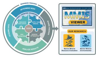
To meet these challenges, BOEM has launched the Marine Minerals Information System (MMIS) as part of the National Offshore Sand Inventory to help to reduce response time in disaster recovery and facilitate long-term planning to strengthen the resilience of coastal communities and infrastructure. Ensuring all parties have access to detailed offshore information is critical to responsible decision-making.
By consolidating offshore sediment data from multiple sources, notably BOEM-funded research, the MMIS offers and interactive tool that provides public access to data and information relevant to offshore mineral resources throughout the U.S. Atlantic, Gulf of America and Pacific OCS.
How do I use the MMIS Viewer?
The Marine Minerals Information System (MMIS) Viewer is an interactive tool that provides access to marine minerals data.. Video recording on how to use the Marine Minerals Information System (MMIS) Viewer.
What Sets the MMIS Viewer Apart?
Part of the U.S. initiative for coastal resilience and marine minerals resource management.
Derivative geophysical and geotechnical datasets essential for leasing, beach nourishment and coastal storm risk management.
A BOEM resource supporting sustainable coastal planning and potential sand availability.
The only viewer that shows Outer Continental Shelf (OCS) lease areas, dredge areas, and shore placement areas.
What is MMIS Meant For?
MMIS helps various users, including scientists, industry planners, government leaders, among others, to make informed decisions.
- Non-technical users
- Project planners
- Resource managers
MMIS provides critical data to support leasing and coastal management projects.
- Engineers
- Scientists (Geologists, Oceanographers, etc.)
- Data analysts
Technical professionals can discover and retrieve data for your analysis.
Where are the Data Coming From?
- Academic Institutions
- Associations
- Councils and Working Groups
- Federal Agencies
- Industry
- Non-Profit Organizations
- Regional Partners
- Scientific Organizations
- State & Local Agencies
- Cooperative Agreements
- Studies
- Contracts with Industry
- Historical Archives
What Information is Available?
- Marine Minerals Offshore Study Areas
- Lease Areas
- Dredging Areas
- Shore Placement Areas
- Sand Resources
- Atlantic OCS Aliquots with Sand Resources
- Gulf of America OCS Blocks and Significant Sediment Resources
- Core Samples
- Grab Samples
- Surficial Sediment Map Footprints
- Isopachs in feet
- Modeled Shoals
- Paleochannel Lines
- Survey Tracklines
- Pre and Post Dredge Survey Information
and many more MMIS Viewer
How are the National Offshore Sand Inventory and MMIS related?
MMIS serves as a key component to provide accessible data for the National Offshore Sand Inventory.